Hiking trail: Lesser-known Gorce
Practical information
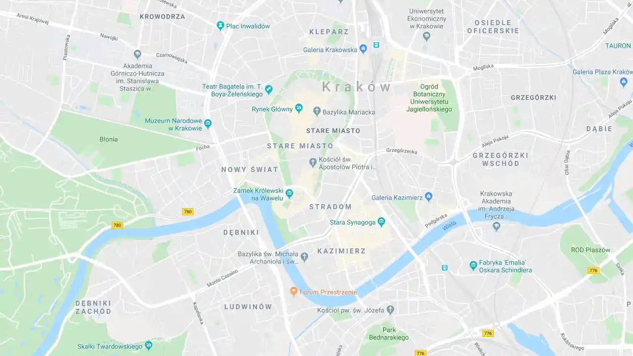
One of the car parks in the Kamienica Valley, details below.
Road no. 968 leading from Mszana Dolna (in the north) to Zabrzeż (in the south). Coming from the north, turn off to the right at the Przysłop Pass, down a narrow local road. Coming from the south, turn left in Lubomierz-Rzeki (just after crossing the bridge over the Kamienica River). The choice of one of the two car parks depends on the availability of spaces and individual preference, and the fee for parking in both locations is similar.
The first option is the car park (or actually two) of the Gorce National Park in the Trusiówka Glade (marked on the map below), recommended for people who want to get to an interesting trail quickly and don’t mind a half-hour hike along a gravel road at the end of the route. The choice of the second site (private parcel) – at the point marked as the start and beginning of the expedition – is suggested to those who want to be in their car as soon as possible after descending from the mountains. The section between both car parks is permitted for vehicular traffic, and you can drive along it.
Time to complete the trail
Moderately difficult, due to its length, the trail requires adequate fitness preparation and taking some food and drinks with you, as there are no shopping or refreshment points along the way. In winter, immediately after a snowfall, it’s very difficult, and there can be sections with snowdrifts.
Please note: From 1 January 2022, within the territory of the entire Gorce National Park, it’s obligatory to buy an entrance ticket. They can be purchased through eparki.pl or in the application mPay. There’s trouble with Internet access in many places in the park, so, when buying your ticket on-line, it’s preferably to download it to your device so that you can present it without hassle during inspection.
Passing by Papieżówka to Jaworzyna Kamienicka
It’s time to go for a hike. Gorce awaits us.
Assuming that we start the hike at a private car park, it’s less than a 30-minute walk to the Trusiówka Glade. We follow the blue trail along the road leading deep into the Kamienica Valley. Being at the bridge on the edge of the clearing mentioned above, we’ll see the second of the parking places described above behind it, and after a dozen or so metres, we’ll enter the Gorce National Park. A nature trail branches off to the left here; we’ll meet it again after a number of minutes.
Starting from the car park on the Trusiówka Glade, you need to subtract 30 minutes from the times given below. That’s how long it’ll take to get from the lower part of the valley to the starting point of the hike in the afternoon.
We’d like to remind you to buy an entrance ticket!
The road continues gently upwards all the time, and after half an hour, it’ll lead us to a clearing with Papieżówka. This is a wooden hut originally used by forestry workers. In August 1976, the then Metropolitan of Kraków, Cardinal Karol Wojtyła, lived there incognito for two weeks while preparing for the Eucharistic Congress in the USA. Since 1978, the year of election of Card. Wojtyła as pope, the building has been called Papieżówka (Pope’s Hut). Next to it stands a plaque with the words of St John Paul II: Look after these trails for me.
A red walking trail starts at Papieżówka, which from now on will show us the way. For 5 minutes, we still move together with the blue signs, but before the next bridge over the Kamienica, we say goodbye to them and turn left. We begin the long (about 3 hours), strenuous ascent to Jaworzyna Kamienicka. There are a few steeper sections along the route, but this is no problem as the road also acts as a cycling route, so it can’t exceed certain limits of slope steepness.
Initially, the trail runs clearly to the west then winds along the slope, changing direction several times before finally traversing the slope clearly to the west, crossing streams in several places. The upper section is particularly picturesque in autumn when the sun breaks through between the trees illuminating the multi-coloured leaves. Gradually, the ascent eases, and a view of the Kudłoń massif, visible on the right, opens up. We’ll see the peak in all its glory when the trail turns left at a right angle, and we’ll find ourselves at the lower end of the Jaworzyna Kamienicka Glade. It’s a good idea to stop here for a while, to even out your breathing, as you face a 10-minute intense ascent to the upper end of the clearing. Having reached it, we find ourselves near the second highest peak in the Gorce Mountains: Jaworzyna Kamienicka (1,288 metres amsl).
At the edge of the glade stands Bulandowa Chapel, one of the symbols of the Gorce Mountains, very often featured in photographs. It was founded and self-built in 1904 by Tomasz Chlipała, known as Bulanda, a famous shepherd, an exceptional figure in the history of the Gorce Mountains, sometimes compared to Sabała from Zakopane. It was said that he could perform magic, predict the weather and that he knew miraculous healing methods. When he came down from the mountains in his old age, he was a wealthy man. According to some, he made his money by selling the cheeses he made and by curing people, while, according to others, he simply found a treasure. There are two versions as to where this treasure was discovered: firstly, the valuables were hidden under a stone in the place where the chapel stands today; secondly, they were under a boulder in Zbójecka Jama (Robber’s Den), a nearby cave.
In fact, this is a small rock crevice with corridors diverging from the entrance a few metres in either direction, and it’s unlikely a bunch of robbers would fit in there. You can find out by yourself by following the red signs to Zbójnicka Jama. The walking time is about 5 minutes one way.
Through the Gorce glades
After one last look at Kudłoń, located on the other side of the Kamienica Valley, and at the viewing tower on Gorc, our next destination, visible in the distance in the east, we set off along the green trail. For about 2 hours, we hike slightly downhill, passing the numerous glades for which the Gorce Mountains are famous. The sweeping views to the south encourage us to make at least a few brief stops and gaze into the distance, especially when visibility is good.
All nice things always come to an end, so our peaceful trek will also be finished. There’s about 30 minutes of intense ascent to Gorc before we reach the lookout tower. When the ascent eases, it’s a sign that we’re close to our destination. This will also be signalled by reaching the place where the trails intersect: the green trail turns right to reach Ochotnica Dolna via Jaworzynka Gorcowska, and the blue trail, starting here, will lead us to the valley of the Kamienica River, from which we set off. From here to the summit of Gorc (1,228 metres amsl), we still have about 10 minutes of walking left. The view from the highest platform of the Gorc lookout tower will certainly reward us for all the hardships of the hike. You can look everywhere around you and understand what you see thanks to pictures with descriptions installed on the inside walls. Even if you reach this spot on a day when the fog limits visibility to a few metres, the tower still has its charm.
Slight problems with orientation
The descent from Gorc to the Kamienica Valley (about 1 hour and 15 minutes) is pleasant, as you’ll pass through several more glades with beautiful views. You need to stay focused at the beginning, as along the route, there are a few places difficult in terms of orientation. The first is already at the very peak: a signpost suggesting we enter a path into the forest; however, you have to start descending simply by the road. After 5 minutes, there’s another important point: by default, you probably would take the road straight ahead when in fact, you have to turn left, into the forest, to traverse the slope to reach the upper end of the clearing, where an uncovered peak called Gorc Kamienicki lies. There are no places in the clearing to place trail markers, so you have to go somewhat intuitively: first up the hill, and from there, head left diagonally to the junction of two forest walls visible below.
The subsequent hike no longer poses any major orientation problems. Maybe only at Nowa Polana Glade (about 1 hour after setting off from Gorce) will you have to be careful not to go straight ahead but to turn left. It’s impossible to miss this spot, as the clearing is located after a section of steep descent and provides a short rest before the next steep descent. Only the last few hundred metres, when you enter the forest road, will be much gentler. On the final straight, you’ll pass the forester’s lodge, cross the bridge over the Kamienica River and find yourself at the starting point.
Those who left their car at the Trusiówka Glade still have to walk for about 30 minutes along a gravel road gently uphill along the Kamienica.